MTC-DGC-DNMG — WEATHER FORECAST FOR THE NEXT FOUR (4) DAYS (29/09/2026–02/10/2026)
🌫️ WIND CONDITIONS (KM/H)
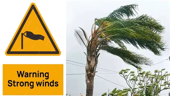
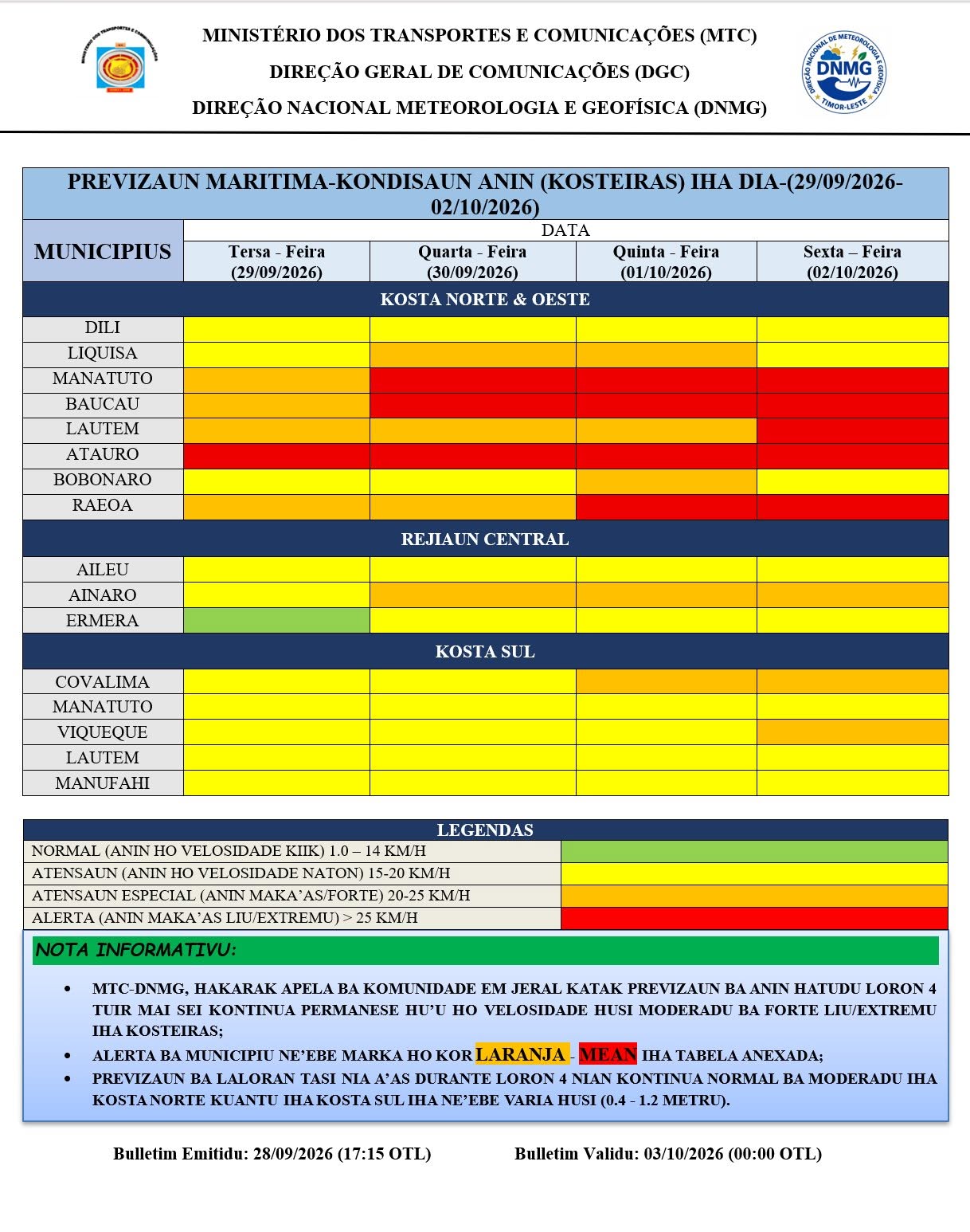
⚠️🌊 DNMG continues to monitor and alert about the intensification of winds, ranging from STRONG to VERY STRONG/EXTREME categories in coastal areas across the territory of Timor-Leste, particularly along the NORTH, EAST, and SOUTH COASTS. ⚠️🌊
The wind intensification is expected to persist throughout this week, varying from MODERATE/normal to VERY STRONG/EXTREME (20–38 km/h) across most of the national territory. More detailed information can be found in the attached table.
🌊 SEA WAVE CONDITIONS (M)
⚠️ ATTENTION TO HIGHER SEA WAVE CONDITIONS ALONG THE SOUTH COAST ⚠️Sea wave conditions are expected to remain NORMAL along the NORTH COAST throughout the week. Meanwhile, along the SOUTH COAST, wave conditions are expected to range from NORMAL to MODERATE (0.4–1.3 m), directly influenced by southeasterly winds.
🌤️ GENERAL WEATHER CONDITIONS
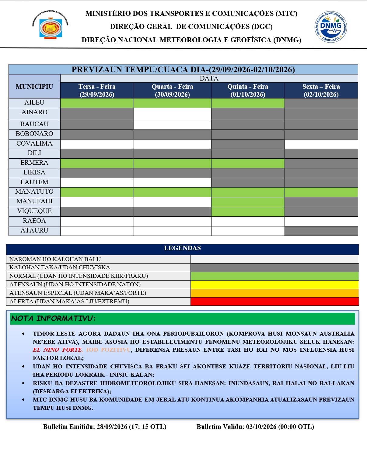
The Ministry of Transport and Communications (MTC), through the DNMG, would like to inform the public that atmospheric conditions are expected to remain generally stable throughout the week. However, the continued presence of the Australian Monsoon, together with local factors such as the topography of Timor Island, is expected to continue favouring light to weak rainfall across most of the national territory, particularly from the afternoon to the early evening.
📢 IMPORTANT MESSAGE
- ALERT: Intensification of winds ranging from STRONG to VERY STRONG/EXTREME is expected in coastal areas, particularly in municipalities marked in orange-RED on the forecast map.
- Fishermen and maritime transport operators, particularly those conducting fishing activities and operating the Dili–Oecusse–Atauro routes, are urged to exercise maximum caution regarding these potential conditions in order to reduce the risk of unexpected accidents and disasters.
- Although sea wave conditions along both the NORTH and SOUTH COASTS are expected to remain NORMAL to MODERATE, the influence of STRONG to VERY STRONG/EXTREME winds could cause wave heights to increase or change at any time.
- In the event of an emergency or if evacuation becomes necessary, remain calm, avoid panic, and follow the instructions of the nearest Local Authorities or Civil Protection personnel.
- Continue to follow the latest weather forecast and extreme-weather updates issued by DNMG Timor-Leste.
- More information is available through the DNMG Timor-Leste website: DNMG Timor-Leste
ADVISORY ISSUED: 28/09/2026 (17:15 OTL)
ADVISORY VALID UNTIL: 03/10/2026 (00:00 OTL)
DNMG-MTC Weather Forecast and Extreme Events Team wishes everyone a GOOD WEEK.
- Valid from
- Monday, 28 September 2026
- Valid until
- Saturday, 03 October 2026
- Published
- 29 Sep 2026, 11:23 · Jacinto Auni
Additional meteorologist notes
OBSERVATION: The above weather forecast is subject to updates. In the event of significant atmospheric changes, the forecast will be updated immediately.